
|
| View Now! |
Tracing the Continental Drift page
I
II
III
IV
V
[ This was written in September 1997 - but edited more
than once since then! ]
As I have just recently read in the German version of the Scientific American - Spektrum der Wissenschaften - scientists have known for long that the sun's photosphere rotates faster at the equator than at the poles.Now here is a theory I have been working on as a hobby for the last 10 to 15 years, since around 1982: That this is a common trait of all rotating stellar objects which are able to do so, be they liquid or gaseous, big or small, from galaxies over stars and planetary systems down to the planets themselves.
This would be because when rotating objects contract due to their own gravity, their core, becoming more compact, begins rotating faster than their surface, a difference that is necessarily most marked at the equator and least at the poles, maybe even forming a vortex there. (1)
It's a pirouette effect.
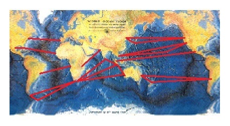
| I came across this idea by looking at a map of our own planet and trying to trace the continental drift by retracing the spreading zones on the earth's surface as shown on the globe. | |
| One of these strange facts, is that there are no mountain ranges on
either side of the Atlantic or Africa or to the south of India, where in
plate tectonics theory they should be, opposing the mid-ocean ridges.
Obviously, no tectonic subduction has taken place to the south of India or west of Africa and Europe and east of the Americas during the last few hundred million years; this concentrates itself to the north of India and in the east of the Pacific, on the west coast of the American continents, and north of the Mediterranean Sea. |
|
| All stationary sea floor spreading mid-ocean
ridges should, in theory, have subduction zones opposing them - and on both
sides, too.
In fact, they don't. There are mid-ocean rifts without subduction, as in case of the Atlantic, and there is subduction without an opening rift, as in Europe or North America. And it's fundamentally asymmetric. There are really only one or two cases in which these subductive requirements are halfway met - namely, the north-south American west coastal Andean-Rocky Mountain ranges, in the lesser mobile north all the way to Yellowstone and Grand Canyon, opposing the mid-Pacific ridge, but only to the east; and even so only until that rift overtakes its own subduction zone and disappears under the northern Rockies. And Japan, as the 2011 tsunami earthquake demonstrated, is moving (south-) east as well, not westwards, as it should be; it is being torn away from mainland Asia, together with Korea and other islands and peninsulas - not crushed into it by the Pacific sea floor spreading even further to the east. |
|
| And the second big recent subduction zone,
the east-west Eurasian Alpine-Himalayan mountain range, does not have a dedicated
mid-ocean rift opposing it; except in the Indian ocean - and the newly forming
African Rift Valley - Red Sea - Jordan rift, which is still in the making, and therefore
could not have moved such masses; the Mediterranean itself, as volcanic as
it is, is not really a rift ocean, missing the mid-ocean ridge; but rather it
belongs to a series of seas, including the Black and Caspian Seas, which
are being torn open (and closed) by deeper forces, as is the Persian Gulf.
This leads to the conclusion that these - in fact all - sea floor spreading mid-ocean ridges are indeed not stationary at all, but instead are being moved along with an eastward magma flow. |
|
| The
only coastal mountain ranges east and west of the (north) Atlantic are
the Caledonian-Atlas mountain ranges, which are not recently subductive,
but an ancient former mid-continent mountain mass, similar to the (new) Central
Asian mountain mass, torn apart - not built up - by the Atlantic rift; all
moving east. |
|
| By retracing the sea
floor spreading and running it forward again, the startling effect
is therefore a clear eastward flow of the continents
along the equator, with a circular hole at the north pole ( more
continental mass being in the northern hemisphere ) and a circular land
mass at the south pole.
The usual animation, exploding Pangea in all directions from Africa, is probably due to our Euro- and therefore, Africa- centered view onto the globe. |
|
My
idea now is that the continents are being carried along by an eastward equatorial
stream in the earth's mantle, driven by the earth's core rotating faster
than the surface.
| There is a
sinus
overlay to this magma flow, which runs - complete with
swirls and eddies - |
|
|
|
| The "scars" of this process are distinctly visible on the ocean floors- and on the continental crust as well. There is a conspicuous straight ( or rather, curved )line from the east coast of Africa and Arabia running up the west coast of India all the way to the north-eastern tip of Asia: | |
Weirdly, this assumed magma flow seems to follow the projection of an "ecliptic" |
|
| [ This gravitational pull of the sun, together with
that of the moon and the rest of the solar system, may
even contribute to the effect of slowing down - or rather, holding
back - the outer shell of the earth. That may even be a contributing cause of
Earth retaining an interior of molten magma at all. Perhaps even the fact that the earth passes nearest the sun when the Northern Hemisphere (and the arctic) is facing it due to the inclination of the earth's axis is contributing to the fact that there is more land mass concentrated in the north than in the Southern Hemisphere ] (2) |
What are the consequences?
I don't know.
It's just an ideé fixe.
( I haven't been able to work this out on a computer yet, just a crude paper model on a Xerox machine years ago. I have made a scan of it which works quite well as an animated gif and can be disassembled again. )
How to get to the results:
The rather simple trick is to reduce bit by bit the sea floor spreading in relation to the mid-ocean ridges.
This only works if the Alpine - Andean mountains (which by now
have lost most of their volume due to erosion) are allowed
to spread out in consequence, and the continents themselves are allowed to
deform - or rather
reform - in the process, since
the mountain ranges of the Alps, once a series of
marine sediment basins, for instance, in part
now lie hundreds of kilometers "inland" from their original location.
Here, plausible assumptions have to be made. Who says the continents have always had the same shape as today? Neev and Hall (3) of Israel did some research on this aspect many years ago but, as far as I know, have met with very little response.
Here, inevitably, plausible assumptions will have to are made about the original expansion of the so treated compression zones; whether they once represented sinks, possibly submarine, and the like. However, the outcome of this drift - retracing (an oblong-shaped Pangea, which extends over both poles), is less arbitrary than it may appear at first glance.
This roughly corresponds with the present-day scientific image, but shows the way to get there - and thus a way to extrapolate this into the future.
Let me put it this way:
| Karachi and Daressalam, had they existed at the time,
would have been neighboring cities; |
 |
|
| as were | Kapstadt, Colombo, Djakarta and Perth; | |
| further east, | Sydney, Wellington and Santiago; | |
| up north, | Mexico and Singapore; | |
| the former | Saigon, Manila, Honolulu and Los Angeles; | |
| above, | Peking, Tokyo, Seoul and San Francisco; | |
| and finally, | Miami, Monterey and Dakar, Boston and Lisbon, Rio de Janeiro and Luanda. | |
| Furthermore, |
|
| The Cape of Good Hope and Cape Horn were one, but no cape. The Drake Street was closed by Antarctica. |
|
| All island chains to the east of the continents were once eastern
coastal regions of these continents,
torn away by the eastern magma flow postulated by me.
There are NO island chains ( or basins, for that matter ) to the west of continental shelves!
This observation cannot be sufficiently stressed.
|
|
| Mountain chains in the eastern regions of continents, as in North and South America, or Asia and Australia, are not subductive, but former rift rims; they always ( ! ) have their counterpart further east across the ocean, symmetrically divided by a mid - ocean ridge or basin. | |
| This process can be seen developing in the East African Rift Valley. | |
| Some of these counterparts have, indeed, turned into the above mentioned
island chains. The Indonesian island chain down to the island of Bali, for example, which seems to be in the west of the Australian Continent, apart from being volcanic, in my model in reality is continental debris that once belonged the eastern coast of Africa, resp. the western coast of North America ( some of it even found in the Rocky Mountains ), and the islands south - east of Bali to the eastern coast of Australia resp. the western coast of South America. I do not know if there is a marked difference geologically in those two parts of the Indonesian island range, but there is a marked biological divide between the Islands of Bali and Lombok. This biological separation between the Asian and the Australian fauna was discovered by Alfred Wallace in 1856, and was in fact named after him. The "Wallace Line", which necessarily runs the whole breadth the Indonesian island empire, indicates a long separation between the two parts, which off-hand look like they have always belonged together; but the strait between them is between 400 and 1500 meters deep and is termed an oceanic "graben". Thus, just as continents may be torn apart and wander across the planet, so they may be joined at the far ends of the world to form something new. |
|
| To put it even more bluntly: the surface of this planet has
but two true
subduction
zones; southern Eurasia and western America. And I am not even sure if they cannot be counted as one, maybe excepting the branch to New Zealand. |
|
| All have traveled far, but not as far as Africa itself; although this is difficult to state, considering it is a round trip; and more than once Africa will be or has been, like the moon sailing around the world, in the place it started from. | |
| The eastern flow then is not weak, but very strong. | |
I am forever trying to find someone who could and would
try this out with a sophisticated computer program, which in principle should
be simple, given the geomorphological data; but so
far nobody seems interested. What do you say?
*View*
Juergen Hinrichs, c/o
JHR@gmx-topmail.de.
Results up to now:
( Made by cutting up and re-pasting and lastly painting over
that famous world map of the continents and ocean floor from the 1960's by
Bruce Heezen and Marie
Tharpe )
SWF |
View the complete moving continents animated
gif as SWF - flash movie ( Size: 1.2 mb ) |
| Download the moving continents animated gif SWF - flash movie with
right mouseclick ( Size: 1.2 mb ) |
|
| Download the animated GIF image with right mouseclick ( or view with left )
( Size: 1.2 mb ) |
|
Slides |
View the complete moving continents animated
Interactive Slide Show and Globe And perhaps compare it with the animation found here. There are quite a few similarities. [ Alas, the size of the continents is greatly exaggerated in my rather rough animation; but in both cases the result is an elongated form of Pangea reaching over the poles. ] |
| Or visit the whole thing on
|
|
|
|
|
| If there is any one out there who would like to try to
work this out directly as a proper
I would be most glad to publish any results on this page. Please contact me. |
|
| For more details, see my next page |
PS:
 I also believe that the moon , for
similar reasons, must have a displaced center of gravity facing earth,
being part of a spiraling gravitational system
that has its center in the earth's core ( and this indeed seems
to be the case ).
I also believe that the moon , for
similar reasons, must have a displaced center of gravity facing earth,
being part of a spiraling gravitational system
that has its center in the earth's core ( and this indeed seems
to be the case ). For more on that aspect, see spacedaily.com or wikipedia on tidal locking See also nature.com for an idea on how thin the earth's crust really is, compared with it's massive interior; and how mountain chains, though the may seem high to us, and indeed have their peaks almost up in the stratosphere, they are but shallow crumples that can easily be formed by the huge forces that hold this planet in it's path. |
|
| Furthermore: The earth's
atmosphere may in prehistoric times have had
2-3 times the volume, pressure and density of today, enabling bigger
and heavier creatures to breathe and fly
( dinosaurs, pterodactyls and before that, gigantic insects and other
arthropods), as well as forming a different climate. Maybe even allowing
for higher mountains by elevating the erosion levels.
More details to that point can be found here. Questions remain:
|
3) Dr. D. Neev,
Dr. J. K. Hall, Geological Survey of Israel, Marine Geology, Mapping
and Tectonics Division 30 Malchei Israel Street, Jerusalem
95 501, Israel
- back -
And now this seems to have been confirmed by new research which apparently hit the news in the August 26 issue of the journal Science, 2005.
![]() Well, well …
Well, well …
They calculated
that the core is rotating approximately 0.3-0.5 degrees faster
than the rest of the earth. In addition there apparently is an inhomogeneity
or "lumpiness" of the inner core.
The inner core has a diameter about three-quarters that of the moon, and a mass about 30 per cent greater than the mass of the moon.
This inner core rotates in the same direction as the earth, but seemingly completes its once-a-day rotation a little bit quicker than the planet as a whole. The studies also indicate that the fast-track axis is not exactly north-south but is tilted slightly at about 10 degrees from the earth's own axis and moves eastward. Over the years, it would trace a circular path around the north pole.
The so-called "superrotation" of the inner core is of the order of 0.3 degrees to 0.5 degrees each year. This means that in about 900 years the inner core would gain one full rotation on the rest of the planet, which would be about 50,000 times that of plate tectonic motion.
( Others seem to calculate around 1 degree per year, which would result in one extra core
revolution in just 360 planetary surface years. )
See
livescience.com on this.
![]() Remember, I did not know of this at the time …
Remember, I did not know of this at the time …
- - -
Does this really mean that the core of the earth is moving 50,000 times faster
than the surface?
No.
In 900 years, which are 900 x 365 or roughly 300,000 days or planetary
rotations, the core completes 1 extra rotation, giving it 1,000003 times
the speed of the planetary surface on the equator
line.
Or 20,000 extra rotations during the 20-odd million years it took that part of Africa once to become India and Tibet to be dragged across the Indian Ocean and rammed into central Asia.
Now that it seems established that there IS a superrotation of the earth's
core, as I had postulated some time last century, maybe someone will be able
to measure its influence on the earth's surface.
As far as I know,
this has not yet been recognised as a possible motor for
the continental drift. One down, one to go.
Then perhaps we can throw some previous assumptions
out of the schoolbooks
- - -
The sad catastrophe of the earthquake and tsunami that hit the main island
of Japan on March 11, 2011
(known as the Tohoku, Sendai or Miyagi earthquake)
seems to have moved parts of the east coast of that country - in
fact, the northern half of that main island - eastwards by some
3 - 4 meters, expanding the country, and parts of
the ocean floor to the east of it by as much as 20 meters
or more
as shown here (taken from
science.org). [ I. e., not westwards ]

Yes, that can be explained by a
rebound effect. And yes, there is a subduction
zone.
Perhaps, though, Asia, and with it Japan, along even with the Pacific Plate, is being carried, pushed and torn (south-) eastwards, - not compressed westwards - the effect being more marked the further east you go, thus opening the Sea of Japan basin, not closing it:
This enhancement of the slippage along the direction of the movement from (north-) west to (south-) east points to crustal expansion, not compression.
The similar would then apply to Australia and New Zealand.
Such would be the rather dramatic consequence of this idea.
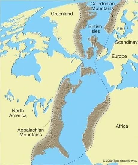
The Scottish Highlands, the Appalachians and the Atlas are not the subduction zones of recent Atlantic sea floor spreading, but form the mountain range that was once connected as the central Pangaean Mountains in an earlier era, formed some 490 - 390 million years ago.
The Mediterranean Sea did not exist at that time, thus allowing the Norwegian Caledonian Mountains to connect further south than today.
- - -
 My Stars! Is it that late already.
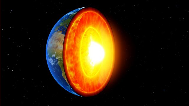
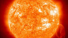
You may want to have a look & listen at the BBC
on the sun
or the earth's core
for additional information.
- - -
To see if the idea that the Earth's core's superrotation may be driving
the Continental Drift is in any way viable, I posed this question to
Grok 3 beta.
****************************************************************************

Zbigniew
Zwolinski, Ph.D.
Quaternary Research Institute, Adam Mickiewicz University,
Fredry 10, 61-701 Poznan, Poland e-mail: zbzw@hum.amu.edu.pl
With two references to this page:
The
Great Globe Gallery on the World Wide Web
( look for "Question for the next Century" )
and
The
Virtual Geomorphology
( look in chapter "Theoretical Geomorphology" )
****************************************************************************
http://www.ngdc.noaa.gov/mgg/mggd.html
look for
"Images",
especially
this
one !
Using this, all you need to have is the specific ages of the corresponding
mountain ranges,
then try to reduce the ocean floor in reverse according to its age!
( It would not yield exactly the same results as my above first try,
but near enough to prove my point; or wouldn't you
agree? )
- back -
1) This would be
an effect of the interaction of gravity and centrifugal force ( leaving
out the effects of dark matter on galaxies ).
Precise measurements by satellites
seem to show that the earth is bulged out slightly at the North Pole, while
being indented slightly at the South Pole. This, if correct, gives the earth
a somewhat pear-shaped appearance. This could be a sign of material being
transported from one pole to the other, probably from South to North Pole
via the core.
[Supplementary: Some wayward thoughts on
thermodynamics,
gravity and human economics]
- back -
****************************************************************************
Lennart
Widmark's site:
http://www.acc.umu.se/~widmark/lwgeolog.html
Some of the very nicest ones are here:
http://www.acc.umu.se/~widmark/lwgeo-ww.html
****************************************************************************
Lutz, T.M., and K.A. Foland 1987, Meridional pattern of the
oceanic rift system.
Geology v.6, p. 179-183.
Busse, F.H., and C.R. Carrigan 1976, Laboratory simulation of
thermal convection in rotating planets and stars.
Science v.191, p. 81-83. >
Kane, Martin F. 1972, Rotational inertia of continents: proposed
link between polar wandering and plate tectonics.
Science v.175, p. 1355-1357.
2) View here also:
Some simple
facts about the interaction of bodies in our solar system
- back -
- The Aquatic Ape Theory ( AAT )
- with:
My personal
contribution to the AAT
and:
|
 |
The SECRET site of an astounded German in the USA
( speaking German, of course )
|
|
Ein erstaunter Reisender in den USA ( deutsch )
|
|
|
Weitere Kommentare zu dieser Seite ( deutsch ) - und ein kurzes Video | |
| |
. . . sowie die Arbeit von Albin Fischer * über die Entwicklung des Klimas seit der Eiszeit - zum ersten Mal on-line! | |
| * Ich mache hier aufmerksam auf die Arbeit von Herrn Albin Fischer, Kassel, zur Klimaentwicklung seit der Eiszeit und sein schönes Poster, veröffentlicht im Orion - Verlag, Bärenreiter - Druck, Buchhandlung Lometsch, Kassel, ISBN 3-9800751-0-9, welches ich auf dieser Seite teilweise eingescannt habe. | ||
|
But there is much more to simple gravity than that:
|
||
|
|
|
|
|
|
The construction and consumption of order in the cosmos. How did everything come to be, and how is it maintained? |
|
The URL of this page is:
http://strangeways.atspace.cc/trace/trace.html
The
original URL of this page was:
http://www.uni-kassel.de/~roehring/Welcome.html,
which clocked up ![]() hits
hits
Sept. 1997 - Sept. 2002 before it sadly had to be abandoned.
Later:
http://www.geocities.com/Tokyo/Temple/5052/mirror.html
And:
http://www.geocities.com/Yosemite/Trails/9846/mirror.html
© JHR
09/1997
Last revised on 15.09.2014
 Page
II : Continental Drift:
Time and distance estimate
Page
II : Continental Drift:
Time and distance estimate
Page
III : Data basis
for flash or morphing experiments
Page
IV : Undulations of
the earth's core
Page
V : Asking AI: Could the Earth's core's extra rotation be driving the Continental Drift?
[ "Descend into the crater of Yocul of
Sneffels, which the shade of Scartaris caresses, before the kalends of July,
audacious traveler, and you will reach the centre of the earth. I have done
it." ( Arne Sagnussem ) - Jules Verne, JOURNEY TO THE CENTER OF THE EARTH ]
ARNE SAKNUSSEMM
 me!
me!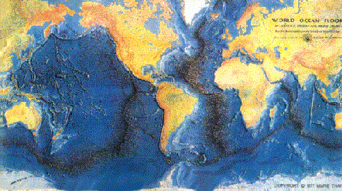