
Tracing the Continental Drift page
I II
III
IV
V
Vogel's
In 1957 Prof. Andreas Vogel of Berlin, then a student, discovered, by calculating
the reflections of earthquake waves on the surface
of the earth's outer core, - in a depth of 2900 km,
or in a height of about 3470 km if measured from the earth's center,
therefore approximately half way up between the earth's center and its
surface - elevations and
depressions of about 10 km, respectively.
Not much, one should think; but these elevations and depressions on the outer
core correspond with anomalies in the gravitational and magnetic fields of
the earth which extend into space, where they can be measured by satellites.
One of these elevations is in the Gulf of Alaska south of Alaska in a depth of 2900 km inside the interior of the earth, further elevations on the earth's outer core are found under the North Atlantic, the Eastern Pacific as well as under Central Asia.
Depressions on the surface of the earth's core are found under the
Philippines, forming a ten kilometer deep valley;
similar valleys found below the North and South Americas,
under India and Siberia, wherever material is being pulled into the
depth.
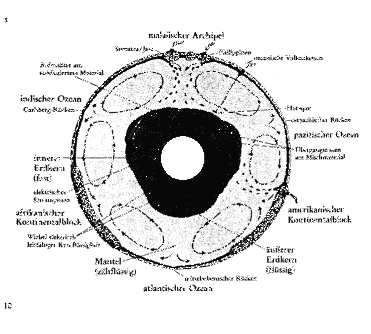
( Schematic model of mantle convection. Approximation and not true
to scale. Cut through the equator level as viewed from
the South Pole )
Taken from: Andreas Vogel, Struktur und Dynamik
der Kern - Mantel - Grenze, In: Physik in unserer Zeit,
Weinheim, / 23. Jahrgang 1992, Nr. 3, S. 111 ff. Abb.
9

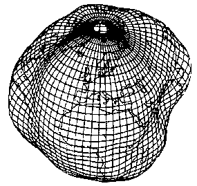
It is interesting now how this affects the earth's surface: According to
sensitive satellite measurements, the earth's surface also consists of three
giant waves and three wave troughs, that apparently seem to be rotating
symmetrically around the planet ( source unknown ).
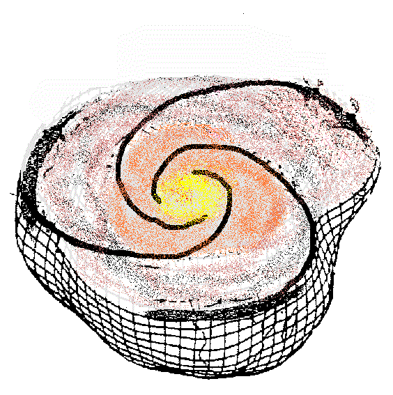
Here both pictures were combined and supplemented by my proposed spiraling
effect of the super - rotation of the Earth's core.
The figure shows a section through the equatorial plane of the earth,
this time as viewed from the North Pole.
Since these waves in cross - section seem to be not of a sinus, but rather of the sawtooth structure of surf waves, they also seem to be moving the around the world eastwards: the heavier, rotating, earth's core pulls the lighter earth's surface along in three waves of molten rock, their crests forming the whitecaps of continental collections.

For reason of a superimposed
sinusoidal
mantle flow apparently following the
ecliptic ( the sun's track on the
earth ) the Americas and Australo - Indonesia are being torn apart
to the Southeast, while Africa and Europe being shoved together to the Northeast.
Antarctica rotates in its place.
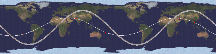
One should not overlook the possibility that the continents might not be moving synchronously with this assumed sinusoidal magma flow, but drift eastwards across its north-south components, as well as the ecliptic is not fixed; so that, for example, Africa now is in the collision range of a northeastern flow with Europe, in which - perhaps some 40-20 million years ago - India was in relation to Asia, which in turn now is more in the range of the northern easterly flow.
To illustrate the postulated sinusoidal
mantle flow; I have superimposed it on the map below ( the thick grey line;
the fine white one depicts another sinus curve, which is set off by about 90°
and supposedly shows a string of locations of
Pyramids
and other ancient artifacts with the red dots; see
here
or
here )
[ A detail of the thrust can be viewed here ]

|
|
The forming of the Darwin Rise [ to illustrate ]
|
More:
Data basis for flash or morphing experiments
Magma flow: time and distance estimate
on Tracing the Continental Drift
Contact:
 me!
me!