
Tracing the Continental Drift page
I
II
III
IV
V
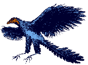
The fossil remains of
Archaeopteryx,
a link between reptiles and birds, and about the size and weight of a modern
crow, have been dug up in
Solnhofen,
Germany.
One could assume that, some 150 million years ago, this used
to be the natural habitat of Archaeopteryx:
However, from the fossil record, one can see that the surroundings in which
this is supposed to have happened were not at all like they are today. Birds,
at least Archaeopteryx, apparently did not evolve in a cool, wooded
northern mountain side environment.
Instead, one can safely say that
| So, to all effects, about 150 million years ago, what was to become the south of the German mainland lay to an open ocean, the Tethys, surrounded by a belt of coral reefs. | |
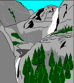
 Rocky, rugged beach landscapes by the sea in which
Archaeopteryx combed the beaches for crawfishes, worms, fish, and
nesting on cliff sites, from where they starting their, maybe, compared with
modern birds, a little clumsy, flights by jumping off the cliff - that seems
to have been that environment. Rocky, rugged beach landscapes by the sea in which
Archaeopteryx combed the beaches for crawfishes, worms, fish, and
nesting on cliff sites, from where they starting their, maybe, compared with
modern birds, a little clumsy, flights by jumping off the cliff - that seems
to have been that environment. |
|
| Archaeopteryx, possibly like all dinosaurs in flight, and modern-day bats, being creatures with no or not yet fully developed feathers, have a difficult time starting off level ground, especially if there is no wind at ground level to throw themselves into. Bats therefore tend to hang on to cliffs, caves ceilings and trees, and so probably did the flying dinosaurs - and so probably did Archaeopteryx. Many of these animals have or had sharp claws with which to climb and hang from. | |
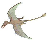 This way, flight developed by jumping off heights
with the help of wind and gravity, not against it ( the question
remains however, how, only 50 million years before,
dinosaurs of maybe 200 kilogram living weight
were able to fly, a feat that is biologically completely impossible
to-day ). This way, flight developed by jumping off heights
with the help of wind and gravity, not against it ( the question
remains however, how, only 50 million years before,
dinosaurs of maybe 200 kilogram living weight
were able to fly, a feat that is biologically completely impossible
to-day ).On the other hand, allowing even for an overall hotter climate, tropical coral reefs do not thrive in the regions of the northern Atlantic, or even Mediterranean, and there also remains the mystery of the missing wood. |
|
| The answer results from the drift distance
of the continental plates moving which, in this region, according
to some sources, amounts to an average of about 37 km northward in
one million years, if not necessarily at a constant rate. So, 140 million years ago, the Solnhofen plate limes lay about 5,200 km more to the south than today, i. e. on the latitude of Cameroon, and, drifting north, some 70 million years ago, passed over the latitude of the Tibesti Mountains in the middle of the Sahara Desert. About that time, the Indian plate began its very rapid northward drift at an average speed of 16 cm / year, covering a distance of about 6,000 km, until the collision of the northwestern part of the Indian passive margin with Eurasia in early Eocene time ( 48 - 52 million years ago ). Since that time and until today, the Indian continent continues its northwards movement at a slower but still surprisingly fast rate of about 5 cm / year - as so does Africa, at about the same speed. |
|
| Therefore, going by the fossile record, the described marine or shoreline habitat of the living Archaeopteryx used to lie somewhere in the region between south of Cameroon and the Tibesti Mountains in the Sahara. Right in the middle of this distance to-day there lies the slowly desiccating and oversalting Lake Chad, and some surviving nile crocodiles still inhabit the few remaining creeks in the shadows of the rocks of those Tibesti Mountains in the in the middle of a huge and impassable desert. But it had not always been impassable. | |
| According to latest findings, 40 million years ago - just about when India collided with Asia - the North African Saharan Desert was, at least partially, a shallow, mangrove - lined floor of the Tethys Ocean, which was raised during the migration of the African Continent to the north - and that from the northern edge, so that whale bones were found in, probably cut off, dried Saharan sea basins, and shell fossils of corresponding age in the limestone of the Egyptian pyramids. | |
| In all these considerations it must be emphasized that the present-day Mediterranean is a centrally 3,000 meters deep sea basin probably torn open by shear forces, as would be the following chain of basins, becoming ever flatter towards the east, of the Black and the Caspian, even the Aral Sea, since the ( still continuously growing! ) Alp Mountains, which were raised out of the sea around the time of about 100 to 20 million years ago, lie to the north of it, while Africa still pushes from the south; yet this sea - other than the one that previously lay to the north of India - seemingly is not being closed by these forces, but torn open. | |
| Impulsed by the African continent, and / or carried off by the
postulated magma flow, Eurasia could now be separating itself once again
from Africa, to the northeast, along the line from England to India.
But it remains a fact that the bed of the former connecting sea, the Tethys north of original Africa, which extends superficially to the Pyrenees and the Alps, and below that surface even further north, indeed has already been closed, and now makes up the chalk and marble Alpine Mountain ranges. And indeed, the rocks that make up the Alps are considered to be of African origin. The African / European boundary, therefore, lies to the north of the central Alpine Mountain ranges, and not south of it - just like the Indian ( former African ) / Asian boundary lies north of the Himalayas. The Mediterranean Sea, along with the Italian ridge, is, geologically seen, part of the African continent, not Europe. 500 million years ago, Africa lay in the South Pacific on the east of Pangaea. About 200 million years ago the north african coast, which was to become part of the Alps, had its greatest extension. Beyond it lay a shallow ocean, at least 500 kilometers wide, and one to the west ( the directions "north" and "west" as seen of today; Africa then probably lay turned slightly clockwise south of the equator as part of Pangaea, it's today's north pointing rather northeast; the present-day Atlantic had not yet opened ). All in all, it is said that the Alps, presently 100 kilometers wide, consist of compressed ocean floor and formerly European and North African coastal regions, which together once were more than 1000 kilometers wide .  This process tilted huge, formerly horizontal rock slabs,
impressive thousands of meters thick, from any angle to vertical, so that,
by chance, footprints of comparatively small dinosaurs - which are said
to be 200 million years old - now run up a rock wall near
Lake Garda in the Italian Alps, once a coral lagoon reef.. This process tilted huge, formerly horizontal rock slabs,
impressive thousands of meters thick, from any angle to vertical, so that,
by chance, footprints of comparatively small dinosaurs - which are said
to be 200 million years old - now run up a rock wall near
Lake Garda in the Italian Alps, once a coral lagoon reef.. On the other hand, the origin of the now lower Variscan Central European mountain ranges north of the Alps - and therefore north of the now closed former Tethys - from the North American Appalachian Mountains to the Urals in the east - which constitute the geological boundary to Asia - and beyond stem from an earlier era, some 300 - 360 million years ago; how far and how long later Western Europe - as well as the Midwest of the United States, and much of Siberia, was below sea level after the breakup of Pangaea, is moot. Deep sea oceans of 1,000 to 10,000 meters depth are indeed former rifts, and often have recent spreading basalt sea floors. However, shallow oceans of a few hundred meters depth, such a the Adriatic, Baltic and North Sea, are not; they are inundated continental shelves. So, the present Mediterranean Sea was probably originally not part of the Tethys, but part of a later North African rift, the edges of which tend to lift themselves upwards. This corresponds with its history of periodic desiccation in the time range of 6-5 million years ago by closing the Straits of Gibraltar ( and, of course, the Sinai ) - similar to the present-day East African Rift Valley. Which, by the way, forces all of mediterranean, southern Europe, i. e. Portugal, Spain, Italy, former Yugoslavia, Hungary and Greece, to be of African origin as well. And one can consider using a 10:1 ratio when discussing how far alpide mountain ranges can be expanded to fill the gaps of disappearing ocean floor while trying to retrace the continental drift. |
|
| Around this time, 5-4 million years ago, another important strait
was closed, the one between the North - and South Americas, changing
the climate on both sides of the Atlantic. The Panamanian land bridge emerged
alongside with humans in Africa, and placental mammals from the north
displaced marsupials, even large ones, in South America ( in Australia,
it seems to have been the other way round; supposedly, because marsupials
can stand harder conditions, with shorter, interruptible gestation ).
In Africa, however, marsupials seem to have been at a disadvantage from the
outset. Madagascar, separated from Africa along with the first Atlantic around
170 Million years ago, has no marsupials, but lemurs, a
primate group that landed there around
70 million years ago. As sediment cores furthermore show, today's Sahara, probably no later than 3 million years ago, turned from a then rainy freshwater - swamp of central Africa type into a desert with the severe climate variations since the beginning of the the so-called Quaternary glacial period about 2.5 million years ago; this is not only due to falling dry by the raising itself, but also to wandering through the trade wind desert belt of the earth. This shifts - probably with the precession of the Earth's axis of about 26,000 years - from north to south and back again; just 7,000 years ago, in the midst of a to-day glowing desert, farmers settled beside a lake. |
|
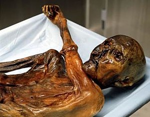 The subsequent transition to a desert took place,
as shown by other sediment cores, about 5,000 years ago, within a mere
100 - 200 years, and the people of the area probably crowded into
the Nile Valley in Egypt to build a highly cultured civilisation;
just at the time when, north of the Mediterranean, in the Alps, a
man with the later name of
"Ötzi
the Iceman" was shot to death and remained buried under snow and
ice for the next 5,000 years. The subsequent transition to a desert took place,
as shown by other sediment cores, about 5,000 years ago, within a mere
100 - 200 years, and the people of the area probably crowded into
the Nile Valley in Egypt to build a highly cultured civilisation;
just at the time when, north of the Mediterranean, in the Alps, a
man with the later name of
"Ötzi
the Iceman" was shot to death and remained buried under snow and
ice for the next 5,000 years. Since then cold and snow rule the Alps, while a mere 2,000 km further south rule drought and heat, separated only by a warm but deep inland sea. Were the Alps warmer when the Sahara was cooler? 10,000 years earlier, the ice age ended on the northern hemisphere; 15,000 years from now the Sahara could be moist and green again. |
|
| But if the former Alpine region lay in place of
today's Africa at that time of
140 - 70 million years ago, then where
lay Africa? This question may not be that uninteresting, as not far from
Solnhofen, in
Messel, the remains of
early primates
of 50 million years and
of pre -
humans some 5-10 million years ago have been found
- which, as we know, originated in Africa. 50 million years ago is, by the way, about the time some small predecessor of the camel went into the sea and turned into the whale, whose earliest fossils have been found somewhere in the Himalayan mountain range ( and later ones in the North African Saharan Desert ). But where did that happen? |
|
| It does indeed seem possible that at the time the Alpine region, and with that the natural habitat of Archaeopteryx, lay not on the southern shores of Europe, but opposite, on the on the southern shores of a northern Ocean ( the Tethys ), which was being pushed up by the African plate and therefore not only geographically on the northern shores of the then African continent, but actually so, the original outline of which continent still show to-day, along the lines of the Pyrenees - Alps - Carpathians - Caucasus - Iran - Afghanistan, telling just how far the former African continent has pushed itself under the Eurasian plate, tilting it to the north and letting the ocean run off, like India under Tibet; this itself all the way up to the Tienschan mountains; both much further than is generally assumed. | |
| A magma flow, which can cause such a thing in such a short time, has therefore to be quite formidable. And such a view would also not prerequisite rigid continental plates unchanging in size. | |
| Perhaps even, at that time, the later Germany still lay under the waters of the Tethys, which also splashed over the North American plains and what to-day forms the Middle East and Arabia - and all of which 140 to 150 million years ago lay much closer to the equator. | |
| Then, the question remains, of whether and how far the whole structure moved along the equator, and if so, in which direction. |

| Amber is found in layers of blue aluminium oxide, in the northern Baltic Sea as well as in the Caribbean Dominican Republic; there, still in those mountains which were reduced to sand, mud and ocean rubble by the glaciers of the ice age in the northern Baltic Sea region. | |
| Amber is about 45 million years old, unpetrified
fossil resin. So, some 45 million years ago, two subtropical blue-clay regions with amber resin trees of various kinds ( which, by the way, also are said to bear resemblance to the flora of south-east Asia! ) lay, if so, then perhaps not very far from each other, which are now separated in longitude by a young ocean and by 30 degrees of latitude, the eastern region being separated from the western one by about 10,000 kilometers to the east and 4,000 kilometers to the north in the last 50 million years. |
|
| The Solnhofen region would then have moved about half that distance extra, the African plate burying itself under Europe, building up the Alps, thus shortening the distance to the Baltic and lifting central Europe out of the sea, tilting it slightly and so letting most of the water run off to the north. | |
| Assuming that in this model the Caribbean Dominican Republic stayed more or less on the same latitude, this gives a rough estimate of the strength and speed of the equatorial magma flow below the crust, in this region of the planet indeed flowing to the north, but at the same time twice as fast to the east. |
| The 10,000 kilometers drift to the east in 50 million
years, multiplied by three in 150 million years, puts
the fossil site of Archaeopteryx and what now constitutes
the northern banks of the Alp Mountains Range in southern Germany
about three-quarters around the world onto what are now
the coral reefs of Borneo and Northern
Australia, and following the
assumed sinus
mantle flow, this fits in nicely with the assumed latitude of that
landscape. We find ourselves again at the height of Cameroon, albeit on the
other side of the planet this time. Addendum 2010: And it puts the original location of the fossil site of the German Archaeopteryx quite near to the Liaoning fossil site on the eastern coast of China ( which lies to the west of the pacific and atlantic expansion, and therefore has not moved, relatively seen ), where mysterious and controversial feathered dinosaur fossils of corresponding age have been dug up - and, oh yes, amber. 150 million years ago, both would have constituted a common habitat - perhaps even a common coast line |
|
| 10,000 kilometers drift in 50 million years would constitute an average of 20 centimeters per year of absolute drift to the east on a surface dragged along by, as others have found, a planetary core completing one extra revolution ( roughly ) every 1,000 years, making its influence felt as an equatorial surface drag of ( equally roughly ) 200 meters per extra core revolution. | |
| In the light of a displacement of trillions of tons of rock by 200 meters every millennium, earthquakes are no wonder. | |
| Would that be too much, and what would it have to be measured against? To try it out: |
|
| Comparing and calculating the Continental Drift as to the possible influence of the superrotating core on the Earth's surface with the help of AI. |
Picture 1:
Assumed mantle magma flow and subduction zones
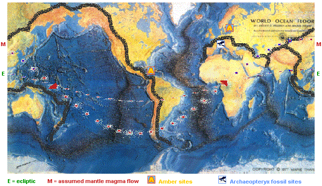
E = Path of the sun's ecliptic ( position of the noonday sun )
M = Supposed west - east magma flow under the earth's crust
Black Borders = Maximum extent of the primary subduction zones - i. e. , the original ( if distorted ) outline of recently subducted continental or oceanic plates.
A = Amber sites
= Presumed Archaeopteryx living site
( roughly; note the similarity in the subduction / mountain chain )
=
Tethys Ocean (?) mineral oil deposits( presumed oil fields, in part, roughly; created from oceanic plankton of the extremely warm Jurassic to Cretaceous period - about 200 to 100 million years ago )
It may be interesting to follow the path of the early hominids ( primates and pre - humans ) drifting along on the African continent, predominantly in the eastern and central, and as it seems, northern parts, albeit of much younger or later origin than Archaeopteryx. Thus making the old world monkeys to new world monkeys.
Undulations of the earth's core
Data basis for flash or morphing experiments
on Tracing the Continental Drift
Revised: 2007
 me!
me!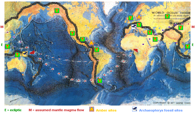